Environment and climate updates, open source tools & technology
tools, community, and training
VTT's Blue Economy Resource Hub
Tools
noaa
Sea Level Rise Viewer 🔍
Visualize potential impacts from sea level rise through interactive maps
This web mapping tool helps visualize community-level impacts of coastal flooding and sea level rise (up to 10 feet above high tide).
It provides photo simulations of future flooding on local landmarks and data on water depth, flood frequency, socio-economic vulnerability, wetland changes, and mapping confidence.
Key features of the NOAA Sea Level Rise Viewer include interactive maps, detailed documentation on data and methods, and easy sharing via email and social media.
Use this tool
Conservation Biology Institute
Data Basin 🌳
Research and learn through this science-based mapping and analysis platform
Data Basin is a global spatial platform designed to improve access to and integration of spatial data while maintaining scientific quality.
It offers an intuitive online mapping and collaboration space accessible via any web browser. Users get a private workspace and tools to support both individual and team projects.
Built for a broad audience, Data Basin puts control in users’ hands, empowering them to make informed, spatially explicit decisions—no mapping expertise required.
Use this tool
Wetlands Watch
Catch the King 🌊
Volunteer crowdsourced flooding data during the Perigean tides
This is an annual crowdsourced science event where volunteers use the Sea Level Rise app to collect flooding data during the Perigean tides—the highest tides of the year.
Tidal flooding threatens coastal communities by damaging infrastructure, endangering residents, and spreading runoff and debris. As climate change accelerates sea level rise, floods are becoming more frequent and severe. Wetlands Watch needs your help to collect critical flood data, guiding local planners and researchers in finding effective solutions.
Learn more
noaa
Heat.gov ☀️
Explore science-backed heat-related informational tools and resources
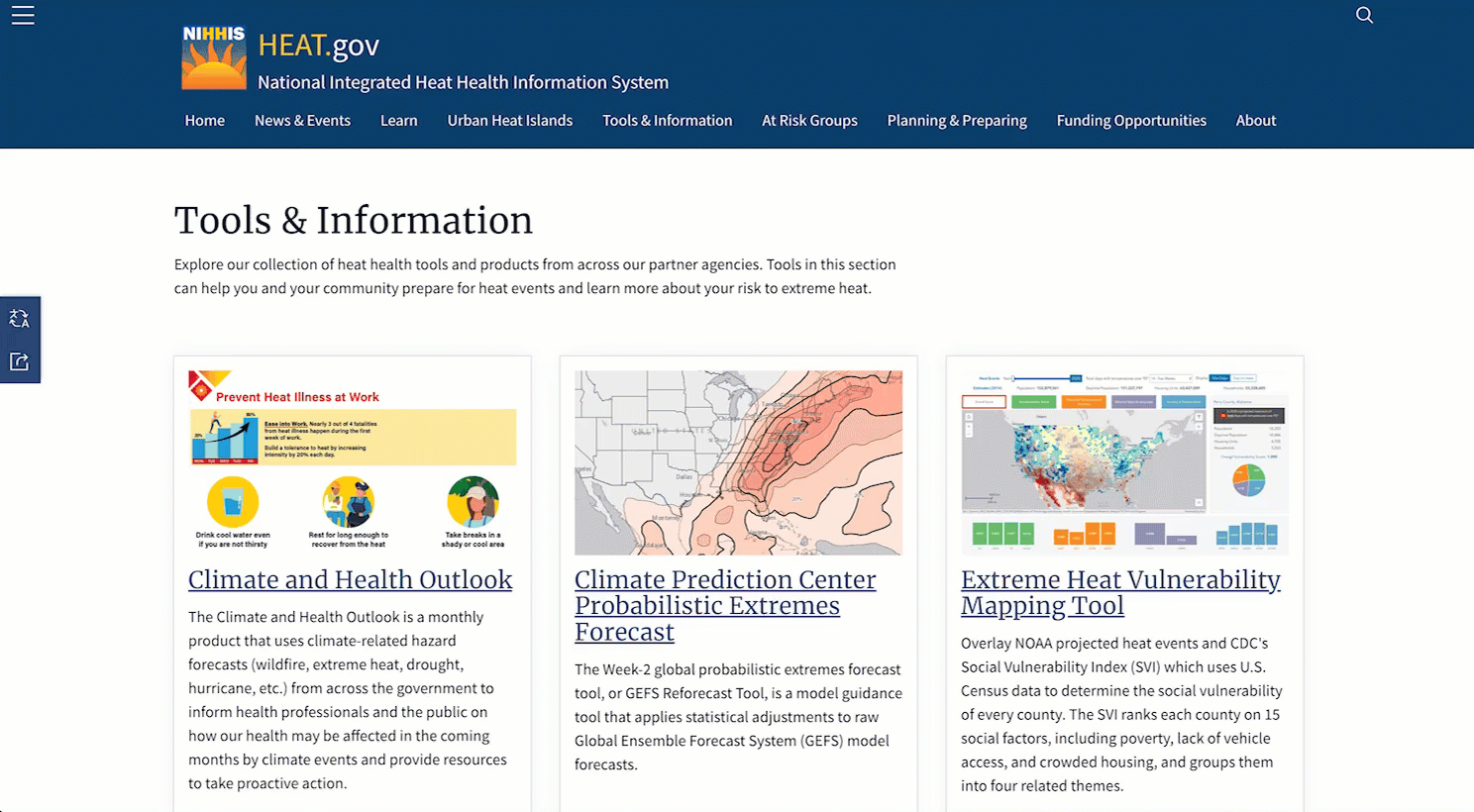
Heat.gov is the nation’s go-to resource for heat and health information, helping reduce the health, economic, and infrastructure impacts of extreme heat through planning, education, and action.
Launched in July 2022 by NOAA and the National Integrated Heat Health Information System, the site provides timely, science-based updates for the public, decision-makers, and media. Key features include real-time heat advisories, NOAA heat forecasts, the CDC’s Heat and Health Tracker, and insights from the Urban Heat Island Mapping Campaign.
go to Heat.gov
united nations
UN Biodiversity Lab 🦋
Examine spatial data to put nature at the center of sustainable development
With over 400 of the world’s best data layers on nature, climate change, and sustainable development, UN Biodiversity Lab supports country-led efforts to use national and global spatial data for planning, monitoring, and reporting and to take action for people and planet.
Explore their interactive map, data collections, workspaces, and dozens of other resources.
Go to UNBL
noaa
Climate Resilience Toolkit ⛈️
Gather science-backed climate information and learn about potential climate hazards
Climate.gov provides climate news, reports, predictions, and scientific data.
Explore their U.S. Climate Resilience Toolkit to identify climate hazards, reduce risks, and protect vulnerable assets.
Key resources include the 5-Step Framework to Resilience, the NCA Interactive Atlas, and climate vulnerability assessments.
Explore the toolkit
noaa
National Hurricane Center Storm Surge Risk Maps 🌪️
Access interactive maps to assess storm surge risk and plan for coastal flooding
These detailed, interactive Surge Risk Maps depict storm surge flooding vulnerability in hurricane-prone coastal areas, extending beyond shorelines.
Covering the U.S. Gulf and East Coasts, Hawaii, Southern California, and U.S. territories, these maps also include parts of Hispaniola and the Yucatán Peninsula, helping communities assess and prepare for storm surge risks.
use this tool
noaa
National Weather Service 🌦️
Get real-time forecasts, alerts, and climate safety resources

Weather.gov is a vital resource for scientists, public agencies, businesses, and climate action stakeholders, offering accurate, real-time weather data and forecasts. It provides critical tools to assess weather risks, monitor conditions, and inform decision-making.
Key features include localized forecasts, severe weather alerts, real-time radar and satellite imagery, and comprehensive safety and preparedness resources.
Go to Weather.gov
Community
vtt
Blue Economy Business Forums 💬
Discover and discuss business community challenges surrounding heat and water-related coastal issues

The Crystal Coast business community is experiencing rising temperatures, stronger storms, frequent flooding, new infrastructure, and housing shortages.
How can we drive transformative solutions to protect businesses from climate-related disruptions? What will it take to build a resilient, future-focused economy? Let’s use our local knowledge and economic insight to develop innovative solutions.
more info
stardust startups
Stardust Startups NC ✨
Meet early-stage impact entrepreneurs launching innovative Climate Action solutions in coastal NC
Stardust Startups NC accelerates innovative Climate Action solutions in the coastal plain of North Carolina through their microgrant program, $500 Coastal Idea Challenge, and other support.
What they do:
- Support entrepreneurs at their early, pre-seed stage with microgrants and visibility
- Nurture human-scale, genuine, continuing relationships with beneficiaries and supporters
- Certify trust in budding projects and pave the way for further funding
learn more
wetlands watch
Wetlands Watch 🌱
Collaborate to conserve nature in a changing climate
Wetlands Watch is a nonprofit based in Virginia driving climate action through policy advocacy and grassroots activism, influencing land use and regulatory decisions at state and local levels.
Their current focus is sea level rise, collaborating with partners to develop innovative land-use models for Virginia’s tidewater communities. They educate and mobilize citizens to push for wetlands conservation policies while engaging the private sector in nature-based stormwater solutions.
learn more
carteret county
Carteret County Chamber of Commerce 💼
Become a member to access networking, publicity, and other resources
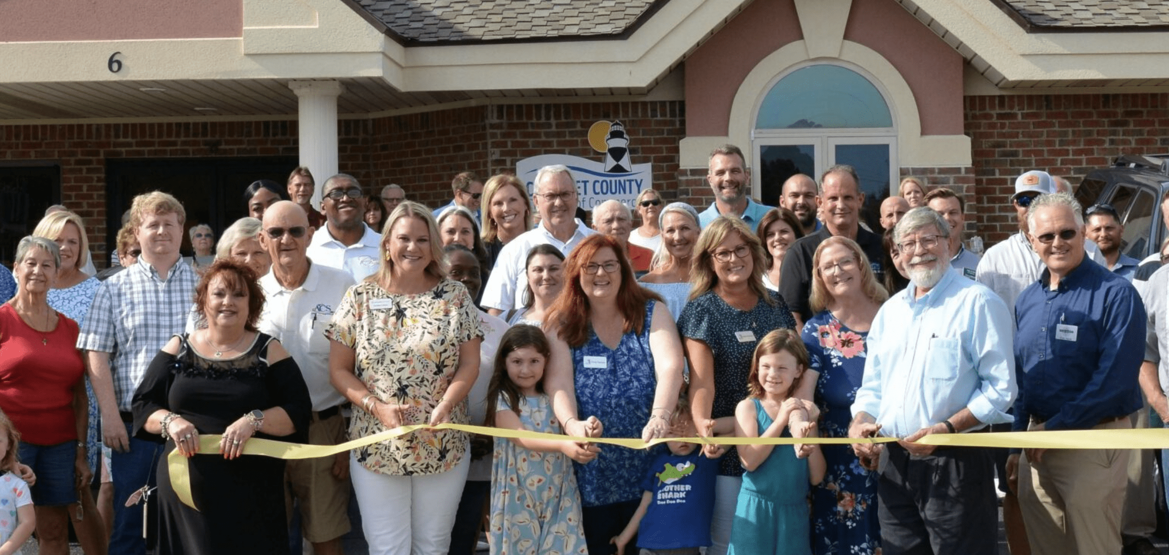
The Carteret County Chamber of Commerce, founded in 1959, represents over 900 businesses, organizations, and individuals committed to a thriving local economy and quality of life. From hosting networking events to advocating in Washington, D.C., the Chamber ensures businesses stay connected with decision-makers as the county evolves.
Member benefits:
- Networking opportunities
- Marketing and visibility
- Referrals and business services
- Education and training
learn more
Training
[coming soon]
See content.
Understand context.
Discover connections.
Evaluate consequences.
quick links
send us mail
P.O. Box 443
Morehead City, NC
28557
email Us
visualteachingtechnologies
(at)gmail.com